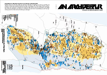
Most maps of the West Bank show Israeli settlements as dots that mark a place and eventually indicate the number of its inhabitants. The map by Rafi Segal and Eyal Weizman, who worked together with the human rights organization B’Tselem, instead shows the shapes and spatial extensions of the settlements. The design of many settlements is derived from strategic targets like the control over Palestinian cities or the obstruction of Palestinian infrastructure. The analyses points out the connection between planning and building processes and human rights violations.
 |
||
| February 2003 16 p., ill.; maps b/w, german |
||
with an interview with Eyal Weizman
english version the interviews